Part 2 - The South Kaibab Trail
The South Kaibab Trail
A Stairway to Heaven
The bottom of the Grand Canyon is about 2500 feet above sea level, temperature during day time average around the mid 50's, early morning temperature is about 37 to 40 degrees. It's cold and nifty but still bearable, it's a clear day with the sun really shining.
The area is so beautiful that it's so hard to bid goodbye, I would love to stay for 2 more nights.
Our wilderness permit is only good for 4 days and so we have no choice but to go back up.
By early morning we break camp and start preparing for an uphill climb of the South Kaibab Trail a strenuous backbreaking hike to the rim.
When your in the bottom of the canyon it's hard to see where the park rim is at, and by observing the first leg of the hike it looks so scary, it's a steady steep incline as we make our way up.
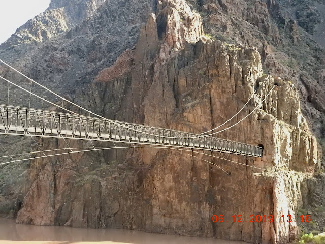
But first we have to cross the Colorado River.
The Suspension Bridge
An Engineering Marble.
The Tunnel
The mules right of way...
The "Mule Train"- Phantom Ranch and the Bright Angels is not accessible by car, so in order to supply the lodge everything have to be brought down by mule including vacationers.
The other way to supply the ranch is by helicopter operated by the National Park Service.
Phantom Ranch is a historical place in Arizona, so popular that you have to reserve a cabin 14 months ahead of time. Kaibab is the trail of choice by the mule team when they bring down supplies.
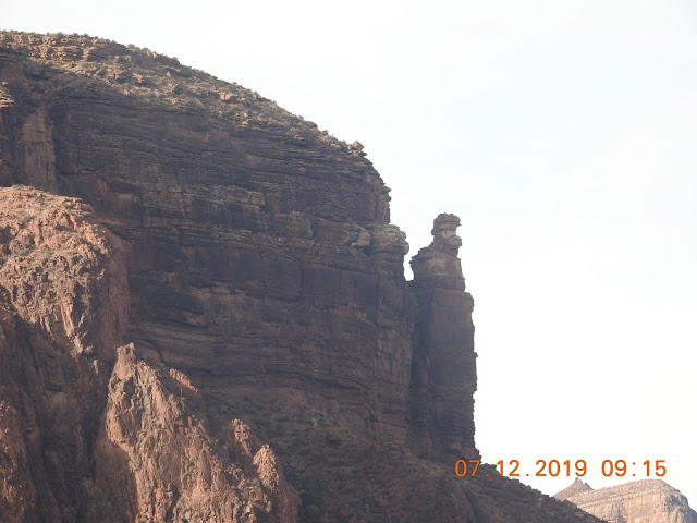
Once you see the spiral rock, that's the sign of the Stairway to Heaven
the beginning of the strenuous uphill climb to the rim.
One last look at the bridge and the tunnel down below, at this point I'm gasping for air trying to acclimate my body. Temperature changes gradually, at the moment I took out my outer layer shell.
At this time my stamina still doing great I'm all in for a fight even do my backpack feels like its getting heavier as we keep on gaining height. A mile feels like forever we're averaging almost two hours to a mile, yes that's 2 hours.
My knees pretty much holding on, my shoes is doing an excellent job protecting my every steps. Every time I look down the view becomes more beautiful.
The beach where the kayakers and the canoe rapids riders will park and rest before heading back out to the river. The river water is so cold a mixed of melting ice and muds and silts.
We have gained about 1200 feet at this point and every so often we have to stop to rest for 2 minutes the most. We still have plenty of water in our backpack but we have to conserve, on this trail there is no water source other than melting the snow to make water.
We are now at "Tip Off Point" at an elevation of around 3500 ft.
The views are incredible even at this point. We have a longggggg way to go.
The wonderful duo.
Down below the canyon is where we started the Bright Angel campground. It's getting smaller and smaller as we climb up for more.
Bright Angel campground and portion of the Phantom Ranch is visible from our point of view, we are about 3500 feet ASL.
The view of the Tonto East - another great trail that crosses the spine of the canyon.
At this point I could see the top of the rim. You can see the snow line along the lower edge, and more snow at the top, that's the tree line where the main park is located.
Very remarkable view from here on.
Photo ops at the Tip Off Point.
The Grand Canyon has it own version of the famous Swiss Alps, the Matterhorn in the background, Gerri and Phoebe enjoying the scenic views.
At this point we are about 4000 feet - we have our lunch break here in a nearby rest area, toilet is available but no drinking water. We catch up with some hikers resting, some are going down and some we're going back up to the rim. We watched the mule train passing thru.
The rest area at the Tip Off Point is designed to shelter hikers from the heat of summer, from a blizzards of snow during winter, wind and lightning protection. Emergency phone is available.
The uphill climbs continue on..
The Tip Off plateau beautiful view from every directions.
We're still a long way to the top we are on our way to the next dizzying switchback .
We are halfway there!!@!@!
THE SKELETON POINT
The recent snow from 3 days ago have melted along the 5000 to 6000 feet ASL. The weather changes from a bearable cold to a windy much colder climate. At this point we need to bundle up time to put on our shell layer and gloves.
The day wears on as we passed by the skeleton point, the cold wind made it worse by an icy rain pelting us we are still roughly about 2 miles to the top. Keep on pushing my strength to carry my loads in my backpack. We ran out of water and the only water source is to melt a snow. Gerri picked up some snows and we melt it with our stoves.
Not a good tasting water but enough to hydrate us for the next mile or so.
As we pushed ourselves more to the side of the cliff hanger I could feel my back hurting a bit, we have to stop so quite often to regain my strength. I might be getting old but heck my backpack feels like about 150 lb's of weight.
We are about 1/4 mile to the top and I just couldn't handle the load, I told Gerri and Phoebe that I may just hide my backpack somewhere and I will pick it up in the morning. But Gerri insisted of carrying it for me for the last quarter mile. There's a lot of snow at this point on the ground and it's very dark, for the last 1.5 miles we've been walking in the dark. We're so glad we have our headlights and flashlight with us. Good gracious Gerri moving right along with my heavy backpack.
We made it to the top around 9:30pm and we are so fortunate we were able to catch the shuttle bus at the trailhead. The shuttle bus is such a blessing, the warmth of the heater blowing and the soft chair and the conversations we have with the driver, we are back in civilization.
I am so grateful that no one got hurt during the arduous climb.
This is one of the best in my hiking book.
The following morning after a good night rest and a hearty breakfast at the Havasupai Lodge.
I went back to the South Kaibab trailhead to take a look on that area where I almost give up my backpack. It's amazing to see the slow quarter mile ascent area of the trail, it seems like it never ends during our walk at night. But it's nice to go back and relived the moment and enjoy the sceneries that we missed during our night walk. I wanted to go down for about a mile, but my instinct tells me not to, I need to get back to the highway for a long drive home. But first a delicious late lunch at steak house in Williams AZ with there famous rib eye.
Time for selfie.
I survived the Kaibab.
A view from the trail up above the snow line.
Absolutely awesome natural bonsai tree, shaped by wind, snow, ice, water, and fire.
The slippery slopes of the Kaibab.
View from the Kaibab trail, the top of the rim.
A lonesome hiker walking through the Cedar Ridge.
The Cedar Ridge begins at about 6800 elevation.
Some of my favorite natural bonsai the Junipers.
The Skeleton Point - taken from above the canyon rim.


Comments
Post a Comment