Pinnacles National Park 2020 Part1
THE PINNACLES
The land of the Ohlone people comprised the Chalon and Mutson tribes that inhabited the area before the arrival of the Spanish Missions. It is believe that the Native Americans have departed the area back in 1810 although there is no written history. When the first Anglo American settlers arrives, the place is a wilderness that is devoid of human habitation. Soon the area becomes so popular because of its magnificent views and natural wonders, it is now being frequented by picnickers from nearby communities, and word spreads out of its beauty. Series of legislations and political maneuverings saved the wilderness area from becoming a private land, at that time it is believe that it is ripe for mining explorations and some other business enterprisers and planners were ready to exploit the possibilities of the place. In order to save the wilderness nature of the park, in 1904 President Theodore Roosevelt signed a legislation to designate the area as Pinnacles National Monument.
More maneuverings for designations and in 1916 the National Park Service finally established in the area paving the way to more protections, conservations, and establishments of trails and enlarging the area to it's present size of 26,606 acres or 10,767 hectares of land. Finally the park became the Pinnacles National Park in 2012. Today thousands of people from all over the states and from around the world comes to witness the beauty of this place.

Driving to the park is quite an adventure in itself, starting from Bakersfield to the I5 North, exiting to W Jayne Ave., going towards the town of Coalinga. Follow CA 198 from Coalinga, but before you do that it's wise to add more gas before heading out or stop by at the local shops along the town to buy provisions that you forgot to bring. This is the last town before heading out to the mountains of San Benito county, comprises of a wilderness and agricultural area. Cattle ranching is the king on this part of Central California, very remote and as you go by, the feeling is like your being reverted back into the era of the wild wild west.

The Airline Highway - CA 25

A carcass of a huge elk's on the side of the road.

The drive is nice except on some winding road, the highway is almost devoid of cars, very rural, mostly cows, deer's, elks, and even wild boars inhabiting the area and sometimes you can see them crossing the highway, or you will see some unlucky road kill on the side of the highway.
Nevertheless the drive is awesome, take your time and enjoy the view, stop at those vistas and take pictures of the beautiful valley and hills. Our trip to the area is during the late fall season first week of December, the whole place is so dry typical of California weather. Rainy season in the area is from December all the way to April. Just imagine this place during spring time it will look like Ireland green.

The park did not charge us for admissions, the East entrance boot is under constructions, but I'm sure sooner or later they will start charging, Merry Christmas gift to us on that day of our trip. Better yet if you love the National Parks you should buy the Annual Pass instead, very reasonable price. The immense popularity of the park are being visited by rock climbers and adventurers from the nearby Bay Area cities, and from rock climbing enthusiast from around the world. The admission revenue will help the park tremendously, the staffs by the way are very friendly folks. We stayed here for 3 days and 2 nights and immensely enjoyed the park and it's trail, and we only covered a portion of it. Although there's so many trails to choose from, but we picked on the obvious choice, the High Peak trail and the Bear Gulch Trail, both trails are connected to a series of other trails in the area, plan where to go before heading out. This coming spring of 2021 if God permits our next trekking will be to challenged the Chalone Peak trail the highest point of the park which around 3400 feet, elevation gain of 2000 feet, that should be really exciting.
The campground narrow one way street.

The Campground
Backpacking is not allowed in the park although this place features one of the best car camping place, lots of secluded area to choose from and they have a "cabin tent" which can accommodate 6 people. Some of this cabins have electricity but it's more pricier than the non electric.
We stayed in one of this cabin and it's a great place to relax after a very long hike.

Cabin Tent - inside, it has beddings 1 queen and 1 twin, 2 lounge chairs and a small table, comfy enough for tired hikers. The beddings does not have covers or blankets, bring your own or just use sleeping bag. The cabin does not have a heater so you may have to bring a portable space heater that is safe and recommended for use inside the cabin. The outside has a picnic table, a fire ring with bbq grill and small patio, very nice set up. You can call the camp store to order firewood to be delivered.

Firewood is available for sale at the Campground Store, and they will deliver it to your campsite. The park does not allow gathering of woods or bringing firewood from outside sources.

The smart raccoons comes out at night, make use of the bear vault provided for each camp.

What's so great about car camping? you can basically bring a lot of stuff that you want to carry, things that you wont normally bring on a backpacking trek.

HIKING THE BEAR GULCH AREA

From the campground head west to the Bench Trail over a mile trail that will merge into the Sycamore trail. Sycamore trail is a lovely canyon trail full of ancient sycamore trees.

The Bench Trail
Is an easy hike that parallels the Pinnacles Highway. You will see wildlife and birds roaming around on this area, mule deer, wild turkey, and local birds. Bobcats and mountain lions also have a presence in this area but very shy animal, witnessing them along the trail is close to impossible. Bears are not present in the area according to the park website info. Rattle snakes are present in the area 12 varieties, a very important animal in the ecosystem of the park, always give a wide berth or keep your distance for safety sake or leave them alone when you're encountering one. Be careful during your hike, be aware of the poison oaks that are scattered all over the park.

Mule deer's.


The Sycamore Trail
This trail goes deep into the canyon as you follow the contour of the Bear creek, the trail mildly going up hill as you approach the area of Bear Gulch. The canyon is a sycamore forest mixed in with oaks, this sycamores are tall and ancient trees that have survives countless wildfires for so many years. Huge leaves and the profusion of yellow, red, and orange color is bursting through the tree tops and into the canyon floor. Sagebrush and chaparrals dominates the underbrush, scrubby oaks along the creek.


What so great about fall weather at the park? The temperature is cool even during noon time, it's a great hiking weather. Temperature early in the morning is in the freezing level, December 6, 2020 the temperature at the campground dip down to 24 degrees and our water bottles became frozen solid. Winter climates gets cooler with freezing temperatures.

When the sun is up, the beauty of the Pinnacles really sparkles.


THE BEAR GULCH THE CAVES AND MOSES SPRING TRAIL
Once you passed the Sycamore Trail, you will pass the trail head parking lot and head up to the Moses Spring Trail. From here on you will see the series of rock formations along the way, as you go further up the spires rises up in the air and you could watch some rock climbers scaling the rocks.


Talus caves dotted along the trail, some of the attraction caves were closed due to the presence of bat colonies that are raising there young's. "The Bear Gulch Cave provides a home to a colony of Townsend's big-eared bats as they rest there in winter and raise their young in the late spring and summer. Townsend's big-eared bats are listed as a "sensitive species" by the state of California, and we are required to protect them. The colony in the Bear Gulch Cave is the largest maternity colony between San Francisco and Mexico." NPS

Talus caves.


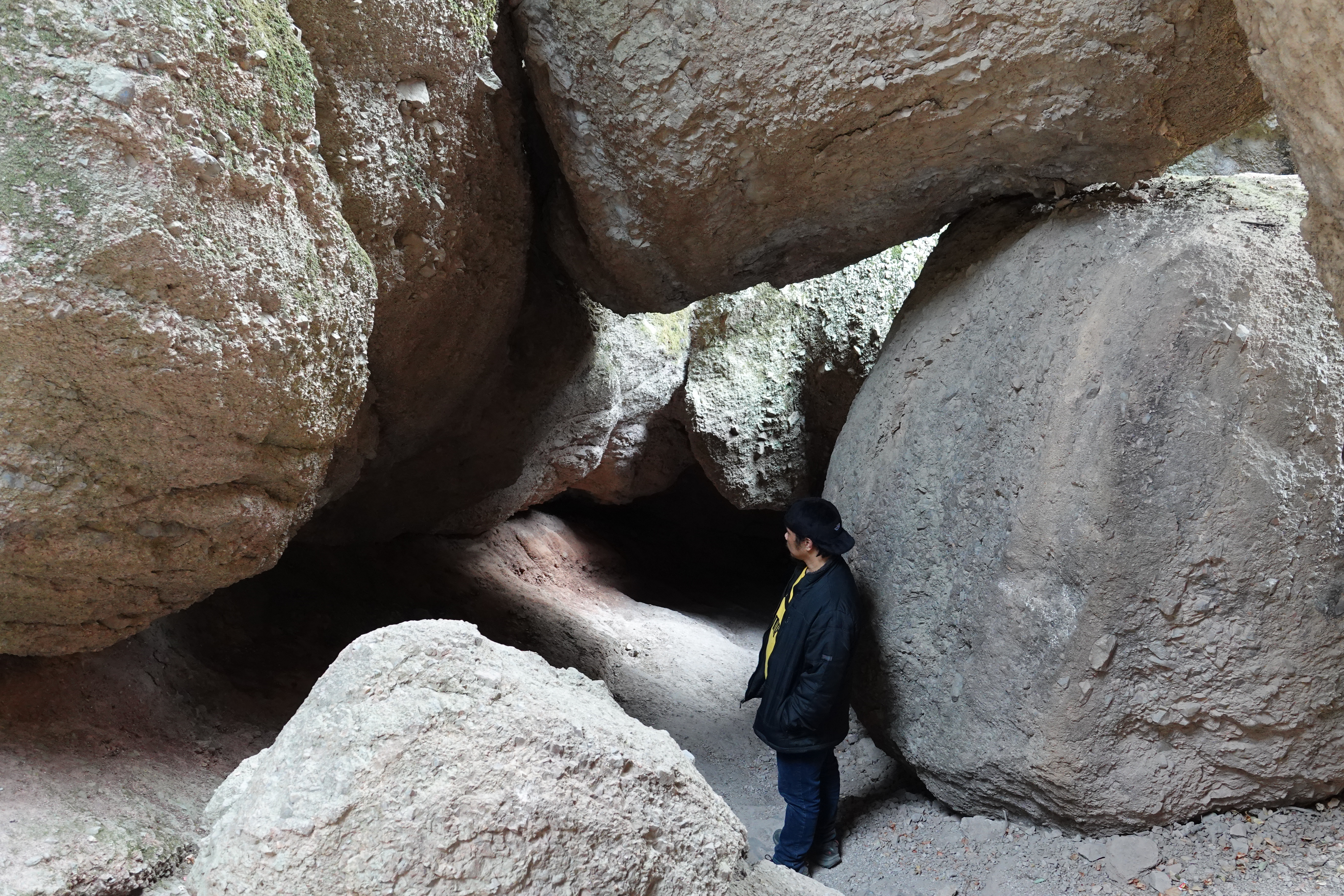


Lot's of interesting rock formations and caves as you traverse through the Moises Creek trail.
From the caves to the stairway to Reservoir. A small lake located at the top of Bear Gulch, this reservoir was built by the hardy hands of California Conservation Corps. The lake will hold water for the whole year, and it's the home of some of the endangered reptiles.
The Reservoir and the work of the mighty Civilian Conservation Corps
The work done by the members of the CCC is still evident here at the park. In 1933, work began at Pinnacles which included the construction of the buildings in Bear Gulch, hiking trails in the park, the fire lookout on Chalone Peak and the bathroom on top of Scout Peak. The famous "Steep and Narrow" trail located in the high peaks with its distinctive steps carved into stone was also constructed by the CCC. Work on the park continued through 1942.
In 1932, Franklin Delano Roosevelt was elected President on the promise of a “New Deal” for the American people. The Great Depression had left millions unemployed, and morale was low across the country. After taking office in 1933, President Roosevelt strove to fulfill his promise by establishing several nationwide relief programs. One of the most successful of these was the Civilian Conservation Corps (CCC).
Info at NPS Website...
https://www.nps.gov/pinn/learn/historyculture/civilian-conservation-corps.htm


The first day of our hikes initially we've planned for an 8 mile out and about trek to the Bear Gulch area, but we indeed up doing almost 14 miles of trails. Long hours of walking, rock skipping, photographing and just enjoying the beautiful view. We got back at the camp when it got dark, lighted up our lanterns, fired up the bbq grill and we cooked a sumptuous dinner and enjoyed a bottle of wine, relaxing and watching the bright stars at night, a cold crisps clear mountain weather and then we noticed that the temperature is dipping down to the low 30's, time to hit the sleeping bag and be ready for another adventure in the morning at the High Peak Trail.


Comments
Post a Comment